Are you weaving your building plans on a dusty plot? But do you truly know what lies beneath? Soil may shift, and slopes may hide in plain sight. One wrong guess could easily stall your dream project.
Land surveys solve this puzzle by mapping every bump and dip, thus revealing hidden hazards. Every builder and every planner depends on land surveys as they cut delays, reduce costs, and keep everyone on the same page.
Now, imagine that power at your fingertips. No more field notes lost or sketches misread. Digital surveys can put precise data on your laptop. Click. Zoom. Examine soil layers. Spin 3D models. Spot faults and fine-tune plans—all information updates in real-time before a single brick is laid.
Meet Axis Surveyors. For 25 years, we’ve led the way in land surveying and geology. But age is just a number. Our team mixes eager pros with seasoned experts. We listen first. Then, we deliver crisp, clear digital maps using drones, GPS, and 3D scans. Fast. Accurate. Reliable.
Your land has a story. We bring it to light. Experience clarity from the very first step. Let’s chart your path together.
What is digital land surveying?
Think of a digital land survey as taking a super-detailed photo of your property—but instead of one picture, you get millions of tiny measurements.
You send out a drone or set up a laser scanner. It “feels” the ground, picking up every bump, dip, and corner. Those millions of dots become a digital map or even a 3D model on your laptop.
Want to know exactly where your fence should go? Or how steep that hill really is? You can click, zoom, and spin the model until you’re confident. No more guessing. No more muddy boots.
It’s fast. It’s clear. And it shows you everything—surface and just below it—before you ever break ground.
Whereas traditional surveys rely on tools like measuring tapes, leveling rods, and theodolites—surveyors marking points by hand on paper.
Who is a land surveyor?
Ever wondered who can turn a rough piece of ground into a clear plan for builders, homeowners, or city planners? Land surveyors walk every slope and valley, measuring elevations, distances, contours, and depressions to convert your landscape into a detailed map on a small piece of paper.
Four key skills of a land surveyor include:
- Technical know-how
- Attention to detail
- Documentation skills
- Good understanding of property laws and regulations
Now, meet the digital land surveyor. They do all of the above—but faster and smarter. Instead of hand-sketching maps, they send up drones, run laser scans, and tap into satellite data. Millions of data points stream into software that builds precise 3D models of your site. You can zoom, spin, and slice through layers right on your screen.
In short, traditional surveyors give you trusted boundaries. Digital surveyors add speed, clarity, and a bird’s-eye view—so your project starts on solid ground every time.
When to do land surveys?
- Before you buy or sell land, to know the exact borders
- When you split your property into smaller plots
- Ahead of building a house, shed, or any structure
- If a fence or wall is going up along the edge
- When you and your neighbor disagree on where the line falls
- Before you apply for a building permit or planning approval
- When laying water, gas, or electric lines underground
- To check for low spots or flood risks on your lot
- If you’re landscaping or adding large outdoor features
- When old survey records are missing or unclear
Why Going Digital Makes Surveys a Breeze?
Super-Accurate Results
Imagine placing stepping stones by a small stream. Digital tools catch every rise and dip. You can do the stone placement works with complete confidence.
See Your Land in 3D
Picture planning a sloped driveway. Instead of flat paper, you spin a 3D model on your screen. You instantly know where water will gather and fix it before you pour concrete.
Easy Team Sharing
Think about emailing paper maps back and forth. It’s slow and messy. With digital surveys, everyone—architect, builder, landscaper—views the same online map at once. Questions get answered in minutes.
All Info Together
Say you have old soil tests, plumbing plans, and new scans. Digital software layers them in one view. You spot buried pipes under a planned path and avoid digging into them.
Faster and Cheaper
Remember waiting for clear skies to survey by hand? Drones and scanners can fly as soon as it’s safe. You get your data faster, cut labor hours, and save on costs.
Digital surveys make every step—measuring, planning, sharing—simpler and smarter. You build with confidence, from start to finish.
Types of land surveys
Before you dive into any project—when buying land, planning a new home, or laying out roads—it helps to know exactly what kind of survey you need. Each type of survey shines a light on different details, from property lines to underground pipes, from slope measurements to zoning rules. Here are the various types of surveys.
- Topographic Survey – Shows the shape and features of land—like slopes, trees, and buildings—for planning and design.
- Utility Survey – Helps locate water, gas, electric, or sewage lines underground to avoid accidents during digging.
- Boundary Survey – Defines where your property begins and ends, based on legal records and corner markers.
- As-Built Survey – Checks if the completed construction matches the approved plan—useful before sign-off.
- Right-of-Way Survey – Identifies land set aside for public use, like roads or pipelines, passing through your property.
- Site Planning Survey – Combines topography and boundary data to design a site layout for permits and construction.
- Construction Survey – Marks where structures like buildings or roads should be built, based on blueprints.
- ALTA/NSPS Survey – A detailed report for lenders and title companies before big property transactions—U.S. specific.
- Legal Description Survey – Creates a written, official version of your property boundaries used in deeds or sales.
- GIS Survey – Collects data for smart digital maps used in town planning, resource tracking, and analysis.
- Fiber Optics & Cabling Survey – (Maps routes for internet or telecom cables—used by service providers for safe installation.)
- Subdivision Survey – Divides a big piece of land into smaller plots, showing streets, lots, and drainage.
- Mortgage Survey – Banks use it before giving a home loan to check property lines and buildings.
- Hydrographic Survey – Maps underwater features like riverbeds, lakes, or harbors—used in marine construction.
- Telecommunication Survey – Helps plan where to place towers or antennas for better mobile or internet signals.
- Demolition & Remodeling Survey – Assesses existing structures before renovation or tearing down—to keep things safe and clear.
- Metes and Bounds Survey – Uses angles and directions to describe rural property where modern mapping may not exist.
- Geodetic Survey – Covers large areas, even across cities or countries—used in big projects and space tracking.
Difference between traditional and digital land surveying
| Feature | Traditional Land Surveying | Digital Land Surveying |
|---|---|---|
| Tools Used | Measuring tapes, theodolites, compasses | Drones, GPS, laser scanners, 3D mapping software |
| Speed | Slower, more time-consuming | Faster, with quicker data collection and processing |
| Accuracy | Good, but may vary with human error | Highly accurate, reduces chances of mistakes |
| Output | Paper maps and hand-drawn sketches | Digital maps, 3D models, interactive visuals |
| Data Sharing | Physical copies shared manually | Easy sharing via cloud, email, or digital platforms |
| Field Visits | More frequent, often repeated | Fewer visits needed due to remote data collection |
| Visualization | Flat, 2D representations | 3D models with detailed topographic and structural views |
| Best For | Small projects or when tech is limited | All types of projects, especially large and time-sensitive ones |
Tools & technology used in land surveying
Gone are the days when surveyors had to rely only on metal chains and tape measures. While those tools had their time, land surveying today looks a lot different—and a whole lot smarter.
Old-school tools like chains and tape
In the past, distances were measured using long metal chains or tapes. It worked but was slow and often needed multiple people to get the job done right.
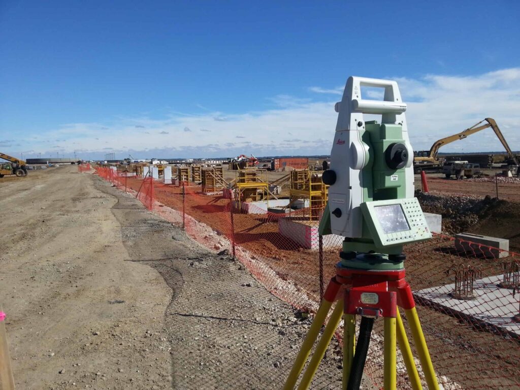
Theodolites and total stations
Then came the theodolite, which was used to measure angles with more precision. Later, total stations took over, combining angle and distance readings in one machine. Surveyors could now work faster, with fewer chances of getting it wrong.
GPS—more than just maps on your phone
With GPS tech, surveyors don’t need to guess. They can find exact locations using satellite signals—standing in a city street or on a rocky hill in the middle of nowhere.
Lidar—lasers that ‘see’ the land
Lidar is like shooting out a bunch of tiny laser beams and timing how long they take to bounce back. That info helps build detailed 3D views of land, even when trees or buildings are in the way.
Drones in the sky
Surveying from above? Drones now do what once took days on foot. They fly over sites, snap high-res images, and collect data that can be turned into accurate maps in less time.
Smart software
Once the data is gathered, surveyors use mapping software to create 3D visuals, overlays, and layered models. It’s clearer, quicker, and easier for teams to work with—on-site or in an office miles away.
Some Best Practices – Digital Surveys
- Begin by clearly understanding what the site or project actually needs.
- Pick tools and software that fit both the job and the ground conditions.
- Don’t skip regular checks—keep all your gear well-maintained and calibrated.
- Make sure your team knows how to use the tech, not just turn it on.
- Always double-check your readings—it saves time fixing mistakes later.
- Keep your systems and software up to date to avoid glitches or errors.
- Pay attention to how your tools perform over time and adjust if needed.
- Organize your collected data so it’s easy to access when needed again.
- Take time to review your results—what worked, what didn’t, and why.
- Always save your work in more than one place to avoid losing key data.
How Can Axis Help You?
At Axis Surveyors, we turn complex land and soil data into clear, usable insights. Whether you’re planning a home, laying out a road, or managing a large infrastructure project, our team makes sure every measurement counts. With more than 25 years of experience and the latest tools, we help you move forward with confidence and clarity.
Who We Are?
We started with a purpose to offer honest, accurate land surveying services that people can rely on. Over the years, we’ve built a solid reputation in Kerala and beyond, trusted by homeowners, builders, and government bodies alike.
What We’ve Worked On?
We’ve had the chance to work on everything from simple house plots to complex infrastructure layouts. Some of our major services include:
- Area surveys across mixed terrain
- Contour mapping for smart design planning
- Road, bridge, and railway surveys
- Soil investigation reports for safe construction
- KSEB line and tower schedule prep
- Earthwork quantity calculations
- Total station training programs
- Drawing and documentation of existing structures
- With over 4,000 projects completed, we’ve likely worked on something similar to what you have in mind.
Why Choose Axis?
- Decades of hands-on experience (25 years)
- Up-to-date tools and digital reports
- Custom solutions for any size of land
- Quick turnaround and reliable support
- Transparent process from start to finish
- Real-time communication during project stages
- Strong track record with both public and private sectors
- We’re not just surveyors—we’re your groundwork partners, helping you plan with purpose.
FAQs
A. We handle both small plots and major projects with equal care.
A. Yes, we provide accurate digital reports.
A. Yes. Our surveys follow industry standards and are accepted by local authorities.
A. We do. From checking stability to analyzing contamination, we offer full soil investigation reports for planning and construction.
A. Just give us a call or drop us an email. We’ll guide you from there.